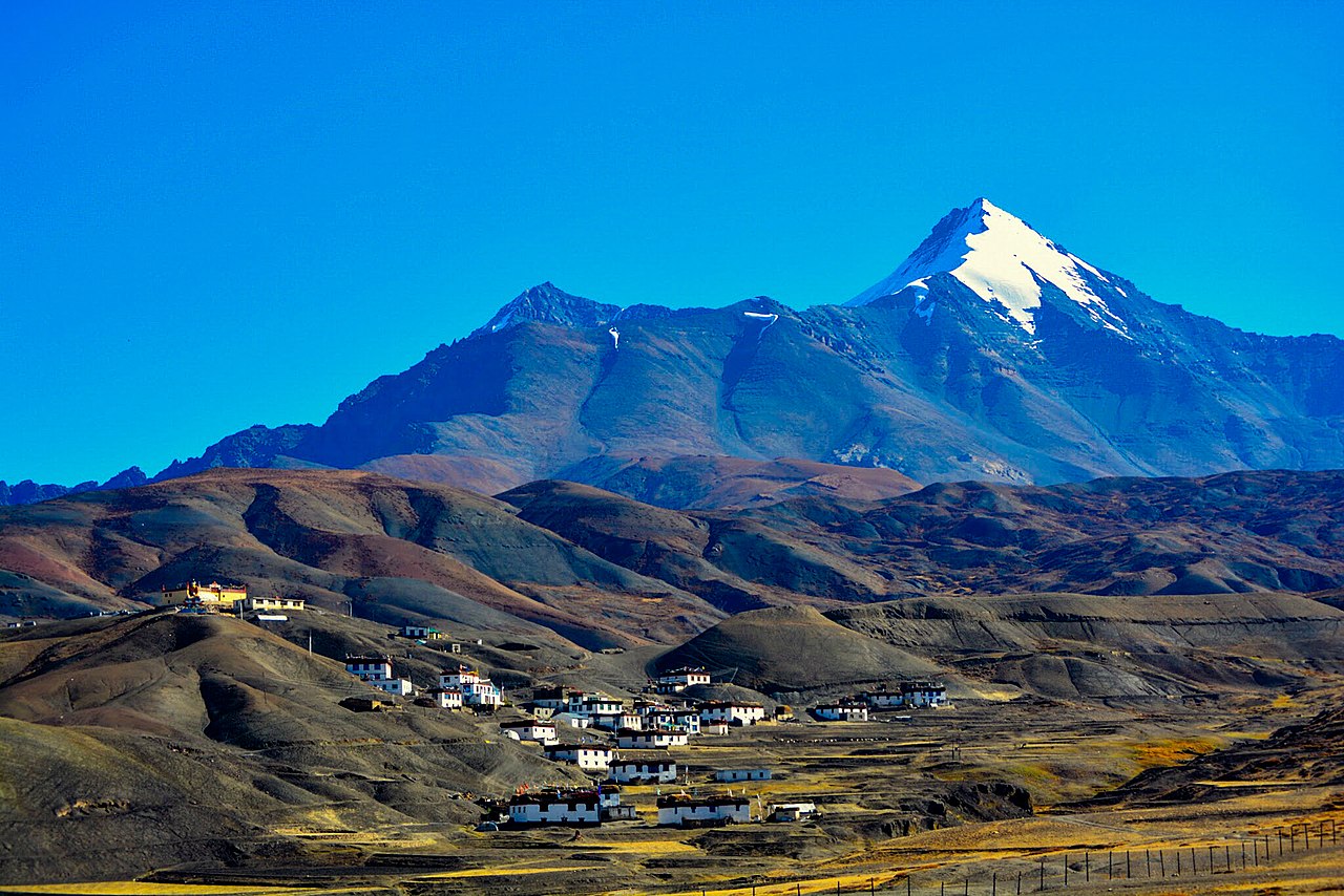
Spiti Valley, HP
Kaza — the base for everything
Sub-divisional headquarters at 3,800 m and the only town in Spiti with a market, fuel, a hospital and mobile signal worth the name. Almost every itinerary uses it as the hub for two or three nights.
Spiti Valley, Himachal Pradesh
Spiti — the cold desert
Thousand-year-old gompas on bare rock, villages at 4,500 m, a lake the colour of glass, and two passes that decide your dates for you. Shimla in, Manali out.
🏔️ Little Tibet
Spiti sits at an average of around 3,800 m in the rain shadow of the Great Himalayan range, which is why almost nothing grows and why the light behaves the way it does. Two roads reach it. The Kinnaur route from Shimla opens early and stays open late; the Manali route over Kunzum Pass at 4,551 m opens in late June and shuts with the first real snow.
That single fact controls everything — your dates, your direction and how many days you need. We are based in Shimla, which puts us closer to Spiti than any operator in Delhi or Manali, and we watch these roads through the season. If your dates do not work, we will say so rather than book you onto a pass that is shut.
Key, Tabo and Dhankar — working gompas, not monuments.
Komic, Hikkim and Langza, all reachable by road.
A glacial lake you camp beside, three km off the road.
Kunzum at 4,551 m decides your season for you.

Key Monastery — 1,000 years
Chandratal — Moon Lake
Langza — Buddha & fossils
The cold desert
Monasteries, record-holding villages, a national park and a lake at 4,300 m. Filter by what you are actually going for.
Spiti Valley, HP
Sub-divisional headquarters at 3,800 m and the only town in Spiti with a market, fuel, a hospital and mobile signal worth the name. Almost every itinerary uses it as the hub for two or three nights.
Icon
Near Kaza
The picture everyone has seen of Spiti — a thousand-year-old Gelugpa monastery stacked up a conical hill above the river. Still a working teaching gompa with monks in residence and murals inside worth the climb.
996 AD
Tabo village
Founded in 996 AD and continuously functioning since, which makes it one of the oldest working monasteries anywhere. Mud-brick halls with original murals and stucco figures — no photography inside, and rightly so.
Cliff gompa
Dhankar village
Built on a crumbling spur directly above where the Spiti and Pin rivers meet. Once the fort of the Nono rulers, now on the watch list of endangered sites. A short steep walk above it leads to Dhankar Lake.
National park
Pin Valley
A cold-desert park holding snow leopard, Himalayan ibex and blue sheep, with a floor greener than anywhere else in Spiti. Trailhead for the Pin-Parvati and Pin-Bhaba crossings.
Fossil village
Near Kaza
A giant Buddha looking out over the valley from 4,400 m, and hillsides full of marine fossils from when this was the floor of the Tethys Sea. Buying fossils is illegal — look, photograph, leave them.
World record
Near Kaza
One counter, one postmaster, and a postbox at roughly 4,400 m that has been running since 1983. Post a card to yourself; it takes a few weeks and arrives with a stamp nobody else has.
Highest village
Above Hikkim
Among the highest villages in the world reachable by road, with the fortified Tangyud Monastery at its edge. Usually done as a loop with Langza and Hikkim in one morning out of Kaza.
Moon lake
Lahaul–Spiti border
A crescent of impossibly blue water below the Kunzum range, three kilometres on foot from the road. Camps sit well back from the shore by rule. Nights are cold and the sky, on a clear one, is the whole point.
4,551 m pass
Lahaul–Spiti
The crossing between Lahaul and Spiti at 4,551 m, marked with chortens and a wall of prayer flags. Custom is a full circuit of the temple before going on. Snowbound for over half the year.
First village
Upper Spiti
The first settlement you reach coming over Kunzum, sitting where the Losar and Spiti streams join. Checkpost, a handful of homestays and the point at which the landscape stops being Lahaul.
Mummy village
Near Sumdo, Spiti
A naturally mummified monk, believed to be around 500 years old, seated in a glass shrine with skin and hair intact. Found after an earthquake in the 1970s and now the reason a very small village gets visitors.
Upper Kinnaur
Mud-brick lanes around a small lake, an eleventh-century monastery complex and willow trees you will not see again for days. The standard overnight between Kinnaur and Spiti proper.
Trek base
Pin Valley
Last village in Pin Valley and where the Pin-Parvati and Pin-Bhaba treks begin. Green fields against bare rock, a few homestays, and no reason to be here unless you are walking on.
Eco village
Near Kaza
One of the villages that built Spiti's community homestay model, where families take guests on a rotation so the income spreads evenly. Yak rides, barley fields and an evening with an actual family rather than a hotel.
Highest bridge
Near Kibber
Asia's highest suspension bridge, strung across a gorge around 120 m deep between Chicham and Kibber. Before it opened in 2017 the crossing was a hand-pulled trolley on a wire.
No destinations in that category yet —
The valley before Spiti
Apple orchards, the Baspa river and India's last village before the border — the stretch most people add on and nobody regrets.
Beyond the scenery there is a practical reason. Entering Spiti through Kinnaur means climbing from Shimla's 2,200 m to Kaza's 3,800 m over four or five days instead of one, which is the single biggest thing you can do to avoid altitude trouble. The scenery happens to come free: Narkanda's deodar, Rampur on the Sutlej, Kalpa facing Kinnaur Kailash, Sangla's orchards and Chitkul where the road simply stops. Two extra days, and the contrast when the green disappears at Nako is the whole point of the trip.
Kinnaur
A green river valley of apple orchards and wooden Kinnauri houses, about as far from Spiti's bare rock as you can get while being two days' drive from it. Kamru fort above the village, and camps along the Baspa.
Last village
The last inhabited village on this side of the border, at around 3,450 m. Slate-roofed houses, a wooden Mathi temple and the Baspa running clear below. The road stops here and the feeling is unmistakable.
Kinnaur
A village of orchards and old monasteries looking straight across the Sutlej at the Kinnaur Kailash range. At sunrise the Shivling rock formation catches light before anything else in the valley — worth setting an alarm for.
Alpine lake
A small sacred lake above Yulla village, reached on a steep walk through meadows and birch. Almost nobody outside Kinnaur goes, which is the appeal — plan it as a full day with an early start.
Season planner
Spiti is not a year-round destination and pretending otherwise gets people stranded. Here is what opens when.
| Section | Best months | Also good | What to expect |
|---|---|---|---|
| Shimla–Kinnaur road | Apr–Oct | Nov–Mar, weather permitting | Open most of the year and usually the first route to clear. Landslide closures are possible after heavy rain in July and August. |
| Manali–Kunzum road | Late Jun–Oct | — | Opens only once BRO clears Kunzum and shuts with the first heavy snow. Never assume it is open before late June. |
| Kaza & the high villages | Jun–Sep | MayOct | Langza, Hikkim, Komic and Demul are comfortable through summer. Homestays mostly close by November. |
| Chandratal | Mid-Jun–mid-Oct | — | Access depends entirely on Kunzum. Camps are set back from the lake by rule and nights drop below freezing even in July. |
| Pin Valley | Jun–Sep | Jan–Feb snow leopard | Trekking season is summer. Winter is for snow leopard expeditions only — serious cold and specialist support. |
| Kinnaur — Sangla & Chitkul | Apr–Oct | Nov, weather permitting | Greenest right after monsoon. Chitkul is snowbound and largely empty through winter. |
| Tabo, Nako & Gue | Apr–Oct | Year-round via Kinnaur | Lowest-altitude stops in Spiti and the most reliably reachable. Tabo stays open when the high road does not. |
| Winter Spiti | Jan–Feb | DecMar | Possible via Kinnaur only, and demanding — limited stays, road closures and −20°C. For experienced travellers with time to spare. |
Why Spiti
Five reasons this circuit keeps getting called the country's best road trip.
An average of 3,800 m. Thin air, hard light and nothing between you and the rock.
Key, Tabo and Dhankar are teaching monasteries with monks in residence, not restored ruins.
No light pollution, no moisture in the air. The Milky Way is visible without trying.
Green Kinnaur to bare moonscape to blue lake in a couple of days' driving.
Community rotation systems at Demul and Langza — the money stays in the village.
Before you book
Roads, altitude, permits and direction of travel — answered the way we answer them on the phone.
Two roads, two answers. The Shimla–Kinnaur approach on the Hindustan-Tibet Highway stays open most of the year and usually clears first, around April or May. The Manali–Atal Tunnel–Kunzum road opens in late June and shuts with the first heavy snow, generally by late October. Peak season is June to September. Chandratal is reachable roughly mid-June to mid-October. Because we are based in Shimla we watch these roads all season and will tell you honestly if your dates do not work.
A full circuit runs nine to twelve days. Shimla in, Manali out, covering Spiti alone, is comfortable in nine. Adding the Kinnaur valley — Kalpa, Sangla, Chitkul — puts it at eleven. A night at Chandratal adds one more. Anything shorter than eight days means gaining too much altitude too fast, and we will say so rather than sell it.
Yes, with the right build. The risks are altitude and road, and both are manageable. We route Shimla in, Manali out so you gain height gradually over several days instead of crossing Kunzum on day two. Vehicles are high-clearance with drivers who work these roads all season, oxygen and a first-aid kit travel with you, and there is 24/7 contact. What we will not do is send anyone with a known heart or breathing condition without a doctor's clearance.
For a one-way circuit, enter through Shimla and Kinnaur and exit through Manali. You gain altitude in stages, see Kinnaur on the way and never drive the same road twice. The reverse works but throws you from Manali to 4,551 m at Kunzum within a day, which is where most altitude trouble on this route starts. If you only have one week, a Manali-in-Manali-out loop to Kaza is possible but tighter.
Chandratal, the Moon Lake, is a crescent glacial lake at about 4,300 m on the Lahaul–Spiti boundary. You drive to a parking area near Batal on the Kaza–Manali road and walk the last three kilometres in. Camping is restricted to a designated zone some distance from the water, which is why the lake is still as clean as it is. Open roughly mid-June to mid-October; tents and transport are part of the package.
One road trip through two completely different landscapes. You leave Shimla through Narkanda and Rampur into Kinnaur — apple orchards, the Baspa river, Kalpa under Kinnaur Kailash, Chitkul at the end of the road — then cross into Spiti at Nako and carry on to Tabo, Dhankar, Kaza, the high villages and Chandratal before dropping into Manali. Ten to twelve days, and the reason people call it India's best road trip.
Indian nationals need an Inner Line Permit for the stretch of Kinnaur close to the border, issued at Reckong Peo or Kaza. Foreign nationals need one for certain Kinnaur and Spiti sections and it takes longer to process. We arrange the paperwork as part of the trip — send scanned IDs well before departure so nothing stalls at the checkpost.
Send the dates, how many of you and whether you want Kinnaur in the route. You get a written itinerary with stay names and an itemised price — and an honest answer if the passes will not be open.